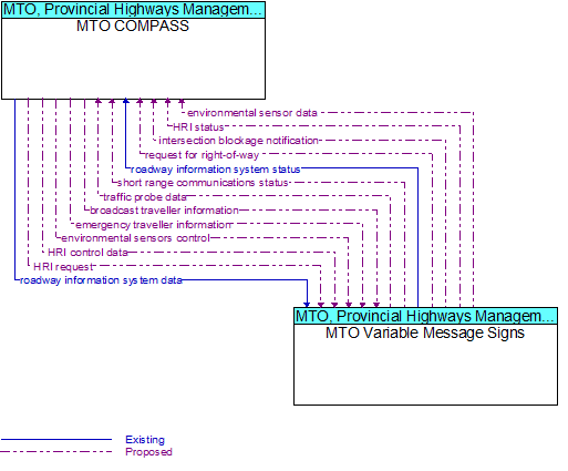
Interface: MTO COMPASS - MTO Variable Message Signs
Architecture Flow Definitions
broadcast traveller information (Proposed) Applicable ITS Standards
General traveller information that contains traffic and road conditions, link travel times, incidents, advisories, restrictions, transit service information, weather information, parking information, and other related traveller information.
emergency traveller information (Proposed)
Public notification of an emergency such as a natural or man-made disaster, civil emergency, or child abduction. This flow also includes evacuation information including evacuation instructions, evacuation zones, recommended evacuation times, tailored ev
environmental sensor data (Proposed) Applicable ITS Standards
Current road conditions (e.g., surface temperature, subsurface temperature, moisture, icing, treatment status) and surface weather conditions (e.g., air temperature, wind speed, precipitation, visibility) as measured and reported by fixed and/or mobile en
environmental sensors control (Proposed) Applicable ITS Standards
Data used to configure and control environmental sensors.
HRI control data (Proposed) Applicable ITS Standards
Data required for HRI information transmitted at railroad grade crossings and within railroad operations.
HRI request (Proposed) Applicable ITS Standards
A request for highway-rail intersection status or a specific control request intended to modify HRI operation.
HRI status (Proposed) Applicable ITS Standards
Status of the highway-rail intersection equipment including both the current state or mode of operation and the current equipment condition.
intersection blockage notification (Proposed) Applicable ITS Standards
Notification that a highway-rail intersection is obstructed and supporting information.
request for right-of-way (Proposed) Applicable ITS Standards
Forwarded request from signal prioritization, signal preemption, pedestrian call, multi-modal crossing activation, or other source for right-of-way.
roadway information system data (Existing) Applicable ITS Standards
Information used to initialize, configure, and control roadside systems that provide driver information (e.g., dynamic message signs, highway advisory radio, beacon systems). This flow can provide message content and delivery attributes, local message st
roadway information system status (Existing) Applicable ITS Standards
Current operating status of dynamic message signs, highway advisory radios, beacon systems, or other configurable field equipment that provides dynamic information to the driver.
short range communications status (Proposed)
Status of the short range communications equipment including the current state or mode of operation and the current equipment status.
traffic probe data (Proposed) Applicable ITS Standards
Vehicle data that is used to determine traffic conditions. In a basic implementation, the data could be limited to time stamped unique identifiers that can be used to measure a vehicle’s progress through the network. In more advanced implementations, th